|
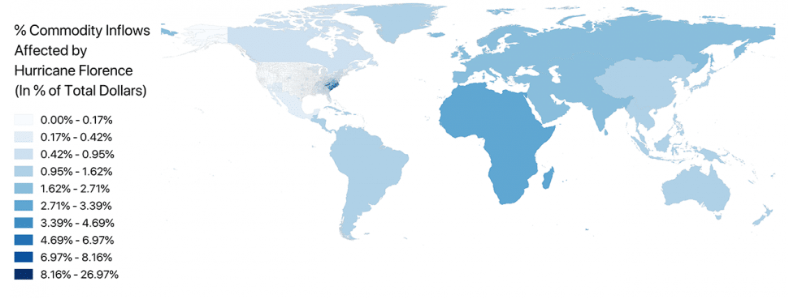
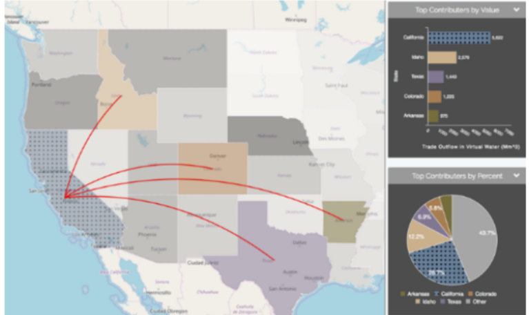
Where does my food come from, and how much water and energy went into its production? How long will we have water if our power fails? How will a hurricane in Texas increase the cost of gasoline in my city? How much will a drought in California impact my food choices? These are the kinds of questions that citizen science project FEWSION (Food-Energy-Water Fusion) For Community Resilience (F4R) is setting out to answer for rural communities and small cities throughout the United States. The project is led by NAU’s Center for Science Teaching and Learning (CSTL) and School of Informatics, Computing, and Cyber Systems (SICCS), and it is currently sponsored by the National Science Foundation. What has F4R already done? Last year, the project started its data collection and procedure development with a volunteer group and an NAU graduate class, who also collected publicly-available data for counties throughout the United States. F4R only collects data on other countries that show their trade with the U.S., and does not track which part of another country traded resources came from or went to. Even so, F4R has already modeled the simplified global impact of disasters in the United States, such as Hurricane Florence. The map above, produced by F4R data scientist Richard Rushforth, is a prediction of the impact Hurricane Florence would have throughout the world. Further information can be found at http://news.nau.edu/fewsion-hurricane-florence/#.XLTtxDBKiUn. Where is F4R heading? This year, more volunteers and students are taking this work and collecting more detailed data for the Flagstaff area. The data collection and analysis F4R will publish will provide some vital information to help communities make informed decisions ranging from what products to buy to environmental legislation and health education efforts. F4R is collecting county-level data on where all these resources are coming from and going to. The Flagstaff research will also be used to help streamline the process for other communities to collect and interpret their data. The feature I am most excited about, “FEW View,” allows you to see where each county in the United States imports its resources from, where it exports them to, and how a disaster in one area may impact another. While it is not yet available to the general public, it currently has a few built-in disaster scenarios, some options for custom disaster scenarios, and options to focus the map on any set of resources and counties you want. An example screen of FEW View from https://fewsion.us/visualization/ shows a state-level breakdown of where California’s “virtual” water is going. Virtual water is the water that was consumed by the production of something else, such as crops, electricity, or manufactured goods. How can I learn more?
All published results so far, more detailed project information, and more can be found at https://fewsion.us/. As a citizen science project, F4R welcomes all interested members of the Flagstaff community to share any helpful information or skills they have. In addition, F4R is hosting an open house on Saturday, April 27th, from 1:00 to 2:00 P.M. in the Downtown Flagstaff Public Library to share some preliminary results and take feedback from our community. Written by Laura Haferkamp
0 Comments
Leave a Reply. |


